
08 March 2021
Measuring 25 by 45 metres, approximately half the size of a football pitch, it was proof that - even in 1973 - not all the landmass on Earth had yet been discovered.
Lying off the Canadian coast was a small mass of rock that all maps of the planet had so far missed: Landsat Island. Its name pays tribute to a satellite that had been launched by NASA just one year previously, on 23 July 1972, the only one able to detect that invisible islet devoid of vegetation or even grass.
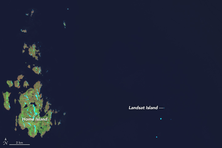
It had been missed by all cartographers, but finally “Landsat Island”, an islet half the size of a football pitch, was detected by chance in the Atlantic Ocean, off the coast of Labrador, in 1973 by the satellite of the same name. Image Credit: NASA-Landsat8-OLI
Landsat-1 had an unprecedented mission: to observe planet Earth from space. It was able to scrutinise the surface in detail, recording changes in vegetation and detecting modifications brought about by man.
In the hands of those with the ability to interpret them, the images captured by the American satellite had infinite potential applications and were worth their weight in gold. Marcello Rodinò, chairman of Telespazio, was well aware of this and did not miss the opportunity it presented.
On 9 May 1974 the Italian company signed a memorandum of understanding with NASA to receive the Landsat data for free in exchange for processing.

The Venetian Lagoon was one of the first Landsat images to be received at the Fucino Space Centre, where a specialist infrastructure for receiving data from the American satellite was inaugurated in 1977.
No longer just telecommunications and in-orbit services, therefore: it was the moment to launch a new line of activity and to build new, bespoke facilities at the Fucino Space Centre.
This was the big bang event for something that within a few decades, above all with the founding of e-GEOS and participation in large-scale projects to protect the environment like COSMO-SkyMed and Copernicus, was to become an identifying speciality of Telespazio: Earth observation and geoinformation.