


e-GEOS, an ASI/Telespazio company, is actively engaged in developing applications, taking part in R&D projects based on PRISMA data.
The company has developed prototype GI products from PRISMA data on forest areas, and in particular forest fire management products such as “fuel hazard maps” through direct and normalised indicators, in line with the bibliographic research of “Università di Milano Bicocca”, which collaborates on the project alongside e-GEOS.
All the data and maps are accessible and managed from the AWARE platform, dealing with the provision of products, services and advanced analytics tools for Critical Assets and Infrastructures monitoring and management.
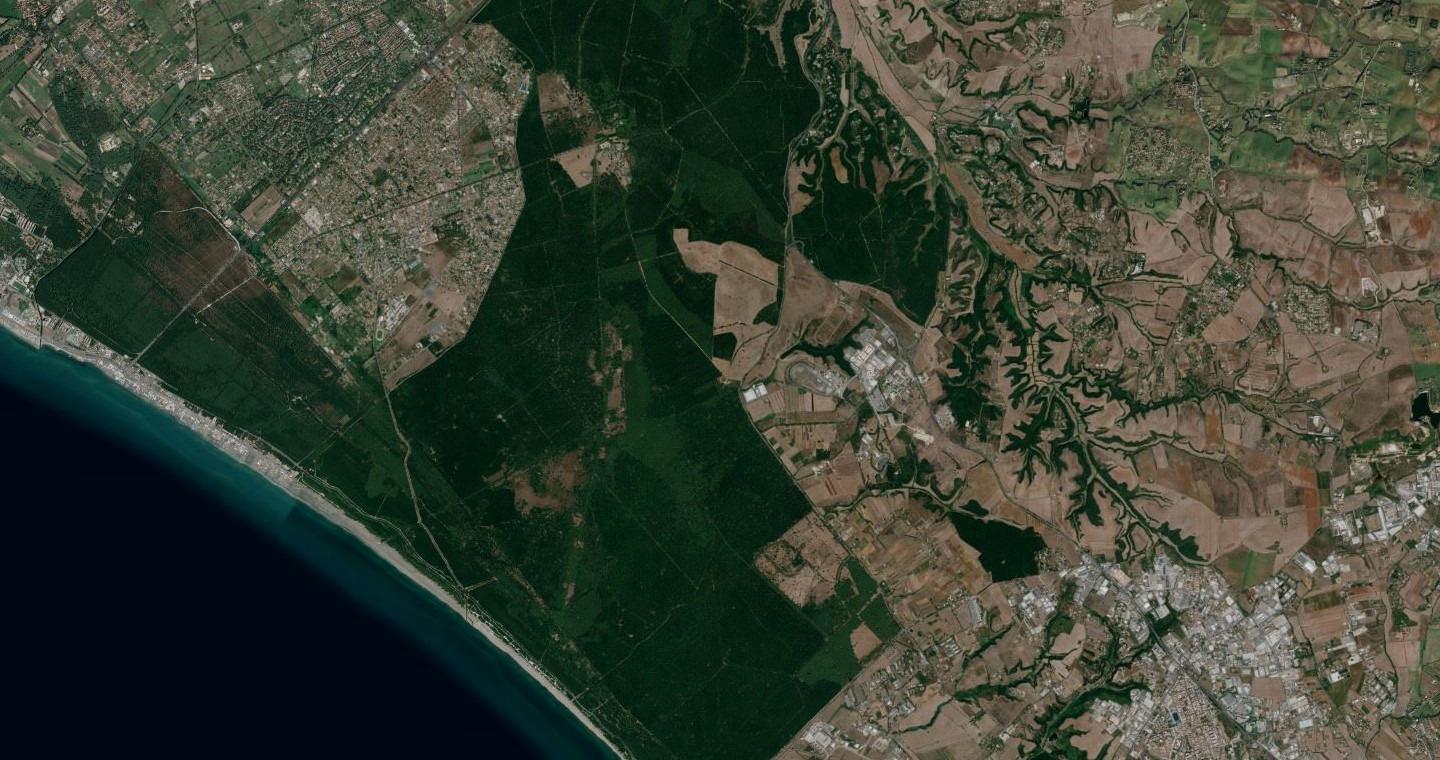
Fire fuel hazard map of Castel Porziano, near Rome, Italy, based on PRISMA data about vegetation status, chlorophyll, water content in forested areas, dry matter prone to burn.
Copyright: Data/Information generated by e-GEOS under an ASI License to Use; Original PRISMA Product - © ASI - (2020-2021)
Product developments dedicated to the monitoring and prevention of fires are also foreseen in the "ASI Project for the Development of Hyperspectral Advanced Prototype Products", of which e-GEOS is the lead partner and in which INGV, Planetek, CNR-IMAA, CNR-IREA, CNR -ISMAR, University of Rome “La Sapienza”, University of Pisa, University of Tuscia participate.
In this project, in addition to fires and vegetation index elaboration, advanced products will also be developed for other application areas, to support monitoring for water quality, for the state and volcanic hazard, for urban and industrial areas, and for the '' identification of hazardous materials.
Moreover, besides participating with the ASI in the main hyperspectral project, e-GEOS also partners the ESA R&D project SES5G (Secure Environment supervisor empowered by Satellite and 5G technology) led by Leonardo, also partnered Siralab, EPG, RadioLabs and TPSSferiacom.
The company also takes part in two R&D projects submitted under the ASI PRISMA science call: PANDA WATER, whose prime contractor is the National Research Council (ISMAR) for maritime applications, and THERA, whose prime contractor is “Università della Tuscia” for land and land use applications.
PRISMA and the Environment
ASI owned PRISMA (Hyperspectral Precursor of the Application Mission) is a cutting-edge Earth observation system, equipped with state-of-the-art electro-optical instrumentation made by Leonardo and incorporating the most powerful hyperspectral instruments in the world.
The high-resolution space and spectral satellites have changed the way we consider the environment and the environmental phenomena; PRISMA is able to distinguish the geometric characteristics of the observed objects and the chemical-physical composition of the surface of the Earth too. In fact, each material has its own spectral signature, an actual fingerprint: a unique combination of colors, named as spectral bands.
PRISMA’s electro-optical equipment is able to analyze this fingerprint from its orbit at an altitude of 615 km, by carrying out a state-of-the-art monitoring which will be able to identify an object, or trace the characteristics of an area under observation.
Specifically, such equipment is made up of an imaging spectrometer, capable of acquiring VNIR (Visible and Near-InfraRed) and SWIR (Short-Wave InfraRed) products, with a 30-meter spatial resolution, and a panchromatic camera with a 5-meter spatial resolution.
Applications of interest include:
-
Detection of materials (also in trace amounts), such as asbestos on the roofs of houses
-
Water quality: characterisation of pollutants (minerals, chemicals, plastics, etc.…)
-
Agriculture: precise characterisation of plant health by monitoring water content
-
Forests: fuel maps, i.e. the mapping of forest fuels subject to fire by measuring the content of chlorophyll, water, dry matter, etc.
-
Various thermal anomalies (volcanoes, thermalism, forest fires)
-
Seas: aiding the detection and characterisation of oil spills
-
Monitoring pollution and environmental changes: characterisation of the state of the atmosphere and of the chemicals it contains
In PRISMA, Leonardo is active along the entire value chain, from the design of instruments, sensors and equipment, to Telespazio's satellite control services and the development of applications with e-GEOS.