


The EMS project is funded by the European Union under the Copernicus programme and coordinated by the European Commission Joint Research Centre (JRC).
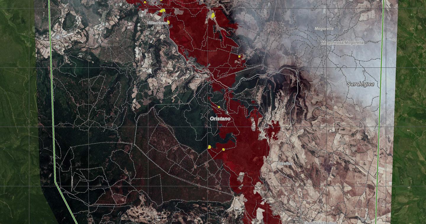
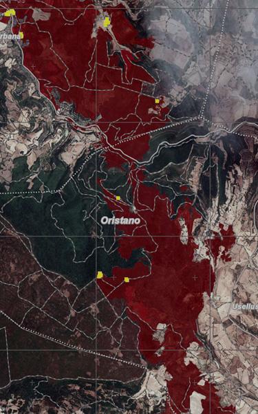
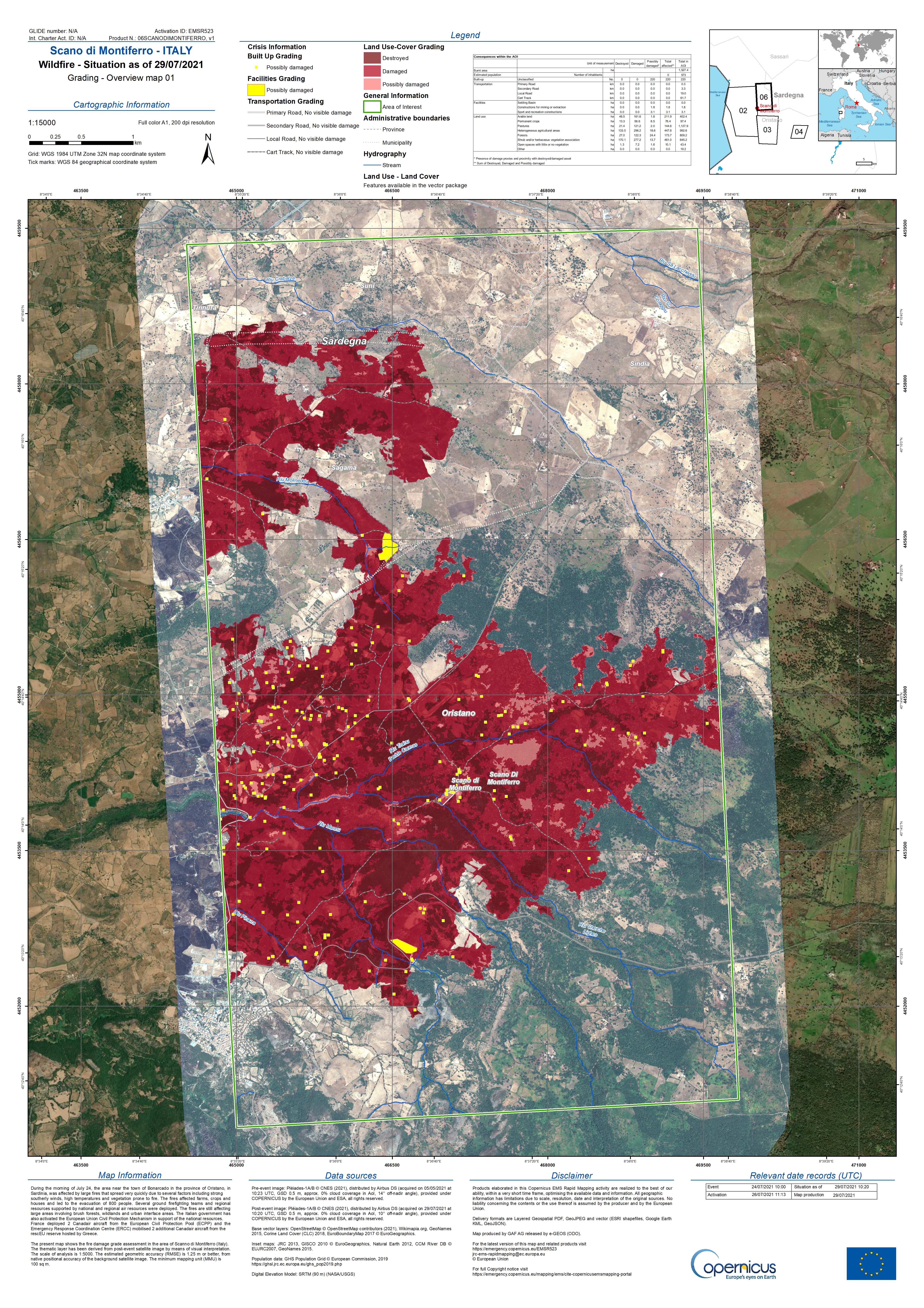
Between 13 and 15 July extremely heavy rain fell in western Germany, Belgium and the Netherlands, swelling rivers and causing tragic floods. On 16 July a fire broke out on the Greek island of Samos. A few days later, another fire broke out in Spain, near the town of Albacete: over 2500 hectares of woods were wiped out in the space of just a few hours. In the following days Sardinia, Sicily, in Italy, and other countries such as Turkey, Greece or Albania have also been tormented by fires.
As well as counting on mutual European aid in the management of these kinds of emergencies, local authorities and civil defence departments can also put their trust in the Copernicus Emergency Management Service (EMS) – Rapid Mappig (RM), the Copernicus programme service that provides rapid satellite maps of afflicted areas.
The RM is able to provide information and satellite maps anywhere in the world, 24/7/365, for all types of disasters, whether natural, meteorological or manmade. These instruments are crucial both for coordinating aid during emergencies but also preventing and mitigating potential adverse events in the future.
To monitor emergencies, the RM places its trust in the data of the Sentinels of the Copernicus European satellite observation programme as well as national Copernicus contributing missions, such as the Italian COSMO-SkyMed or the French SPOT missions – to name just two – which provide their data, if required.
Since its creation in 2012, the EMS – Rapid Mapping service has provided maps and information for over 520 events. The service is managed by the European Commission – JRC and the map production is entirely delegated by to an European consortium led by e-GEOS (80% owned by Telespazio, 20% by the Italian Space Agency) that also involves GAF – a 100% e-GEOS company – and Telespazio Ibérica.
Lucia Luzietti, who manages the e-GEOS team dedicated to the service from the Rome Emergency Room, told us how they work and how satellite data can help us prevent and mitigate future emergencies.
The EMS – Rapid Mapping Emergency Room can receive lots of requests in a very short space of time. How do you manage such a large amount of work?
The Team that supplies the Copernicus EMS RM service was organised in order to deal with peaks of activity that can occur in the event of major emergencies, like the one in northern Europe, or in situations in which the Team has to deal with different emergencies at the same time. More specifically, we can activate up to 7 different Production centres in Europe at the same time, each of which identical to the next, to ensure a large production capacity 24/7. All of this is coordinated by two Emergency Manager Teams overseen by e-GEOS and SERTIT, a French company that is also part of the consortium.
How does the activation process work?
The activation process is very quick because the most crucial aspect of a Rapid Mapping service is promptness. The Emergency Manager receives a new request to activate the Copernicus EMS Rapid Mapping service via email from the Emergency Response Coordination Centre (ERCC), the 24/7 control room of the European Civil Protection Mechanism in Brussels, and this is followed by an alert call together with information on the event, areas of interest and the type of analysis useful for the User. The Team gets to work immediately, defining all of the production details directly with the user of the Service in the first two hours so as to finalise, through the European Space Agency, the order of the first satellite acquisitions available on the areas requiring monitoring. For Authorised Users that want to access the service the procedure is very simple and consists of filling out a document that must be sent to the ERCC via email which finalises an analysis of the new request and an authorisation process, downstream of which the request is sent to us as Providers of the Service.
Which other entities are involved in the activation process?
Lots of entities are involved in the activation of the Rapid Mapping service. Once again there is the ERCC, which not only contacts us in the event of new requests but also supports us throughout the entire activation process, as well as the European Commission Joint Research Centre (JRC) for more technical aspects. Users are also key protagonists as, thanks to their help, we have the opportunity to collect feedback directly from the people working in the field and therefore to gain a better understanding of requirements and plan production more effectively. There is also the ESA, which is in charge of the satellite data provision thanks to the important contribution of the Sentinels and the Copernicus Contributing Missions. Finally, there is us, the Providers of the Service, with the Coordination Team and the various Production Centres.
On a planet that is undergoing major climate changes, how can we use satellites to prevent future disasters?
Satellite data is a valuable source of information today. In particular, the quantity of data available enables us to study how a territory responds to certain events in terms of damage to the population, to infrastructure etc. in a very detailed way. Understanding past extreme events therefore enables us to correctly plan risk mitigation measures and prepare better for extreme events.