Satellite Data

Telespazio, through e-GEOS’s CLEOS platform, offers a vast portfolio of satellite data from the world's best constellations, both synthetic aperture radar (SAR) and optical.

CLEOS is a true cloud digital marketplace that, using artificial intelligence and Big Data analytics, can offer easy consultation and purchase of data as well as development of applications and analysis reports.

Synthetic Aperture Radar (SAR)

e-GEOS is the exclusive worldwide distributor of radar data from COSMO-SkyMed, the dual Earth observation constellation owned by the Italian Space Agency (ASI) and the Italian Ministry of Defence.

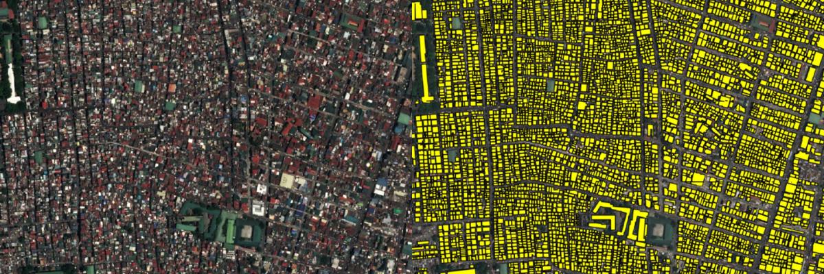
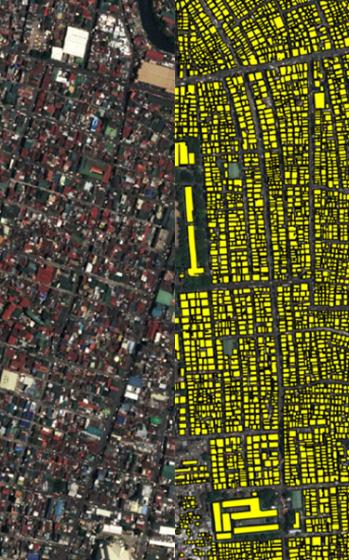
Equipped with X-band sensors, COSMO-SkyMed's first and second-generation satellites represent the state of the art in radar technology and, thanks to their high resolution and low revisit times, make it possible to offer services and data of the highest level.

COSMO-SkyMed data integrate perfectly with that of SAOCOM, the Earth observation constellation of the Argentine space agency CONAE and equipped with L-band sensors, as well as with data from third-party missions in Telespazio, e-GEOS and GAF's portfolio.

24/7 reliable monitoring

High and Very High resolution 

Complementary bands for more accurate analysis

Easy access and ordering via CLEOS

  • COSMO-SkyMed The most advanced SAR satellites

    e-GEOS is the worldwide exclusive distributor of COSMO-SkyMed Products, the most advanced and performing Radar Satellite constellation available today, and operates, on behalf of ASI, the IC-UGS (Italian Civilian User Ground Segment) at the Matera Space Center.

  • SAOCOM L-band SAR

    The Argentinian SAOCOM constellation, developed by the National Commission for Space Activities (CONAE), is composed by two high-resolution, quad-polar SAR L-band satellites, called SAOCOM 1A and 1B.

  • TERRASAR-X / TANDEM-X X-Band SAR

    TerraSAR-X “TSX” and TanDEM-X “TDX” are two German X-band SAR satellite missions implemented through a public-private partnership between the German Aerospace Center (DLR) and EADS Astrium GmbH. 

  • RADARSAT 1/2 C-Band SAR

    e-GEOS is a Network Station Partner of MDA Geospatial Services for RADARSAT-1 and RADARSAT-2, the Canadian commercial SAR satellites, with reception and processing capability at Matera Space Centre, Italy.

  • ALOS-2 L-Band SAR

    ALOS-2 (DAICHI-2), developed by JAXA (Japan Aerospace Exploration Agency), is the third Japanese JAXA L-SAR satellite mission providing data continuity to be used for cartography, regional observation, disaster monitoring and environmental monitoring.

  • KOMPSAT -5 X-Band SAR

    KOMPSAT-5, X-band satellite is part of the Korean National Development Plan of MEST (Ministry of Education, Science and Technology) which started in 2005. The project is being developed and managed by KARI (Korea Aerospace Research Institute). 

Optical

Leveraging its distribution agreements with the world's leading optical constellations, Telespazio, e-GEOS and GAF also offer a wide portfolio of optical data, at very high, high and medium resolution.

From low to very high resolution

Global coverage

Best in class commercial constellations

Easy access and ordering through CLEOS

  • BlackSky Very High Resolution

    e-GEOS is an official world-wide distributor of the whole BlackSky Inc. products and services offering, which include very high resolution optical satellite imagery and analytics.

    The BlackSky Global Constellation offers high-revisit, high-resolution, low-cost imagery for world-wide site monitoring and understanding global activity. 

  • Maxar Very High Resolution
  • Airbus Very High and High Resolution
  • SuperView Very High Resolution

    SuperView-1 (SV-1) is composed of four identical VHR EO satellites running along the same orbit at 530 km and phrased 90° from each other acquiring imagery with 0.5m resolution and 12 km swath width. 

  • KOMPSAT Very High Resolution

    KOMPSAT (Korean Multi-Purpose Satellite) program is composed of a family of satellites built and operated out of South Korea including KOMPSAT-3A, KOMPSAT-3 and KOMPSAT-2. All three satellites carrying electro-optical sensors capable of acquiring very high-resolution full-color imagery anywhere in the world. 

  • EROS Very High-Resolution

    The EROS NG™ Constellation is one of the world’s most powerful intelligence collection assets, designed to meet modern day’s demanding operational challenges, introducing Ultra-Sharp imagery and wide area collection capability at an unprecedented revisit rate. 

  • GEOSAT Very High and Medium Resolution

    Since its launch, GEOSAT-1 has build a huge archive covering billions of square kilometers. Imaging the entire United States in just two weeks, GEOSAT-1 might be considered a replacement to the former Landsat 7 satellite.

  • IRS Medium and Low Resolution

    e-GEOS, through its 100% owned company GAF AG, has direct access to the fleet of Indian Remote Sensing Satellites. GAF AG is the only actor in Europe to successfully receive, archive and market Indian Earth observation satellite data.

How to order

Order on e-GEOS's CLEOS, the largest satellite imagery archive

Order now