COVID-19: e-GEOS will develop a solution to monitor the economic recovery

03 September 2020

e-GEOS has signed a contract with the European Space Agency (ESA) for the development of a solution capable of integrating and analyzing large amounts of  both satellite and non-satellite data, to help monitor the economic recovery after the COVID-19 outbreak, in particular in the port, logistics and freight transport sectors.

The project, called “COVID-19 economic impact assessment from Space in Italian Ports and Logistic Centers - Enabling Industry Growth”, will be funded in the context of the permanent ESA call “EO Science for Society”, aimed at supporting solutions and services using Earth Observation data for the benefit of citizens.

e-GEOS will lead a team composed of the startup CherryData, spinoff of the Politecnico di Milano, and the company ExpertLAB, headquartered in Rome.

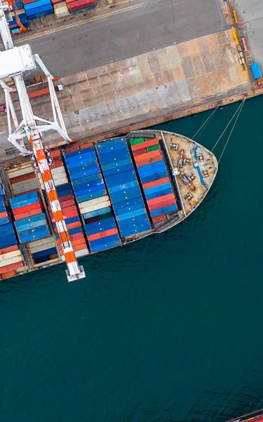
Thanks to a specific big data management and analysis approach, the solution is able to integrate current and historical data from different sources - optical and radar satellite images, information on road traffic, on pollution and on the presence of mobile phones - to analyse and compare trends in the economic activity in the period from 2019 to 2020 and identify future trends.

The solution therefore identifies some indicators in order to characterize the effects of the lockdown and the subsequent gradual return to normality, such as for example the number of ships arriving or leaving a port, as a data representative of the changes in progress.

Thanks to the ability to analyse data from different sources and related to different stages of the crisis, the solution will also be able to monitor and quantify data related to the recovery of the economic activity. The information generated may provide useful information to institutions and entities, in particular to banks, insurance and transport companies.

Data related to some of the largest ports in the country will be analysed, allowing for a potential global scalability.

“This project demonstrates e-GEOS's ability to integrate multi-source information and technologies such as artificial intelligence, big data analytics and computing tools to provide innovative solutions and tools to support institutions’ decisions,”

Paolo Minciacchi, CEO of e-GEOS

Leonardo, through e-GEOS, after providing maps and data to support the management of the COVID-19 emergency through the activation of Copernicus EMS Rapid Mapping, continues to develop innovative solutions in the field of geo-information to deal with the pandemic through the integrated data analysis.

Other News & Stories

09.10.2025
Winners of the Telespazio Innovation Award 2025 Announced in Rome

Engineering creativity and tangible space applications: the joint Innovation Award by Telespazio and Leonardo’s Space Division returns, celebrating the most visionary and promising projects of 2025.

06.10.2025
Renewed Assignment to Telespazio and e-GEOS for the Operational Management of the COSMO-SkyMed Satellite System of the Italian Space Agency (ASI) and the Ministry of Defence

Telespazio, as lead company of the Temporary Business Grouping (RTI) with its subsidiary e-GEOS (a joint venture between Telespazio and ASI) as partner, has been awarded the renewal of the Operational Management and Maintenance in Operational Conditions (MCO) activities of the COSMO-SkyMed satellite system, the Earth observation radar programme owned by the Italian Space Agency (ASI) and the Ministry of Defence.

26.09.2025
Telespazio leads the development of MINERVA, ASI’s national project for GNSS monitoring dedicated to drones

Telespazio plays a central role in the development of MINERVA, the project entrusted and funded by the Italian Space Agency (ASI) for GNSS signal monitoring in support of drone and remotely piloted aircraft navigation within Italian airspace.

24.09.2025
The Leonardo Group brings its excellence and innovation in Earth Observation to Australia

Leonardo, through e-GEOS, will introduce its high value-added Earth Observation solutions to the Australian and Indo-Pacific markets. The adoption of the most advanced geospatial technologies in the region will contribute to strengthening national resilience, environmental monitoring and digital transformation processes.