SEonSE Platform is now online: Satellites and Big Data analytics provide new eyes to protect the sea

Farnborough  17 July 2018

SEonSE (Smart Eyes on the SEas), Leonardo’s geospatial maritime security platform, implemented by e-GEOS, goes online today. Thanks to the use of cloud computing and of advanced big data analysis models, SEonSE makes it possible to access in real-time, even from tablets or smartphones, customised information on what happens at sea.

The announcement was made at the “Farnborough International Airshow exhibition being held in the United Kingdom.

This platform integrates data coming from multiple sources and provides multiple services for maritime security and surveillance, monitoring of illegal traffic, environment protection as well as fight against piracy.

“With SEonSE, maritime security can fully leverage on the advantages offered by digital technology. A huge amount of data is automatically processed in real-time for the protection of people and the maritime environment” declared Luigi Pasquali, Leonardo’s Coordinator of Space activities and Telespazio’s CEO. “This revolutionary platform is based on the knowledge of an industrial Group, Leonardo, a leader in the development and supply of integrated systems and technologies for maritime domain awareness, and on 25-years of experience in the Earth observation domain, with e-GEOS as an international leader.”

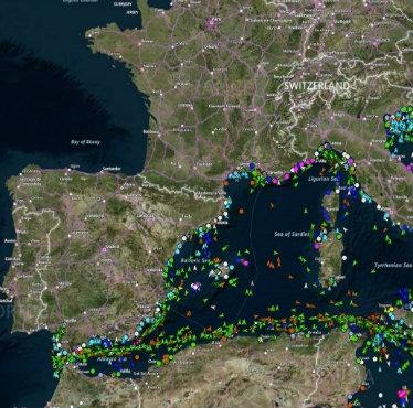
SEonSE processes information acquired from satellites and coastline radars and merges them on an automatic and continuous basis, thanks to proprietary algorithms, with positioning data sent by vessels (AIS, VMS, LRIT), registries of ships and various databases along with meteorological and oceanographic information. This data is then compared with historical information and customary behaviors, making it possible to identify anomalous activities and potential threats to security. The result is timely and easily accessible information, crucial to identifying possible risks which are signaled by automatically generated alerts to intercept the vessel in question, to plan the actions of the relevant authorities and to trace secure routes in hostile environments.

Crucial in terms of security and monitoring is the contribution of satellite images, which allow the observation on a global scale of cooperating or non-cooperating vessels – therefore even the ones that do not comply with identification requirements at sea – in any weather conditions, in remote areas, by day and night.

SEonSE, in particular, combines the high resolution and the flexibility of the Italian COSMO-SkyMed radar satellite constellation with the frequency of programmed acquisitions of the Sentinels of the Copernicus European programme. In addition, the platform already allows the integration of data generated by the constellations of mini-satellites, like Planet and BlackSky, granting a non-stop and complete updating of the situation at sea.

SEonSE also leverages on, in real-time, over 7 million AIS signals sent every day by about 165,000 vessels which are managed by exactEarth, a worldwide leader in satellite AIS data services, for global tracking of commercial ships. e-GEOS and exactEarth have signed a partnership agreement , at the Farnborough show.

SEonSE is based on an e-GEOS’ patent for the processing of satellite data, already used in many activities for maritime security and in international projects, like OCEAN2020, the European Defence Fund’s strategic research programme for naval surveillance technology and maritime safety.

Other News & Stories

15.04.2025
ENAV and Telespazio bring together key Italian players in Advanced Air Mobility at Fucino

At Telespazio’s Fucino Space Centre, the future of drone flight is already a reality: successful demo day for the European project U-ELCOME

10.04.2025
Telespazio Supports PinKamP 2025: An Initiative to Engage Young Women in STEM

Telespazio supports PinKamP, an initiative promoted by the University of L’Aquila and aimed at high school girls, with the goal of encouraging them to pursue studies and careers in STEM (Science, Technology, Engineering, and Mathematics).

25.03.2025
Viasat Selected to design lunar orbiting satellite system alongside Telespazio

Viasat to lead the lunar orbiting satellite communications portion of ESA’s Moonlight Program,  alongside Telespazio and a host of other European and UK companies. Project creates Europe’s first lunar orbiting satellite network.

12.03.2025
Telespazio and ABS Expand Partnership to Enhance C-Band Connectivity in Brazil

Telespazio and ABS (Agility Beyond Space) are strengthening their collaboration with the introduction of new C-band connectivity solutions tailored for the Brazilian corporate market. By combining Telespazio’s advanced ground infrastructure with ABS’s satellite capacity, the partnership aims to deliver high-performance connectivity services designed to meet the needs of businesses.