January 2019


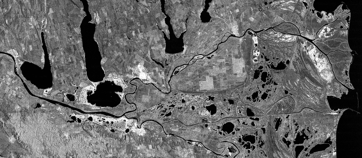
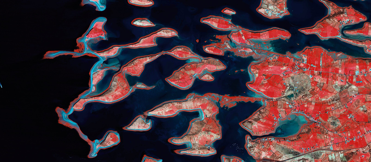
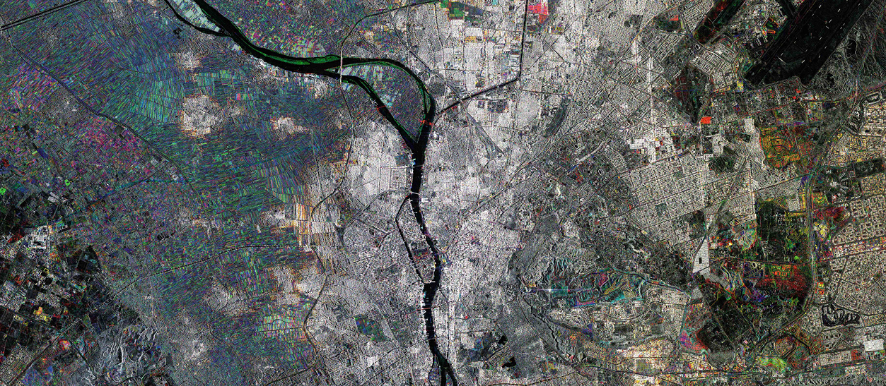
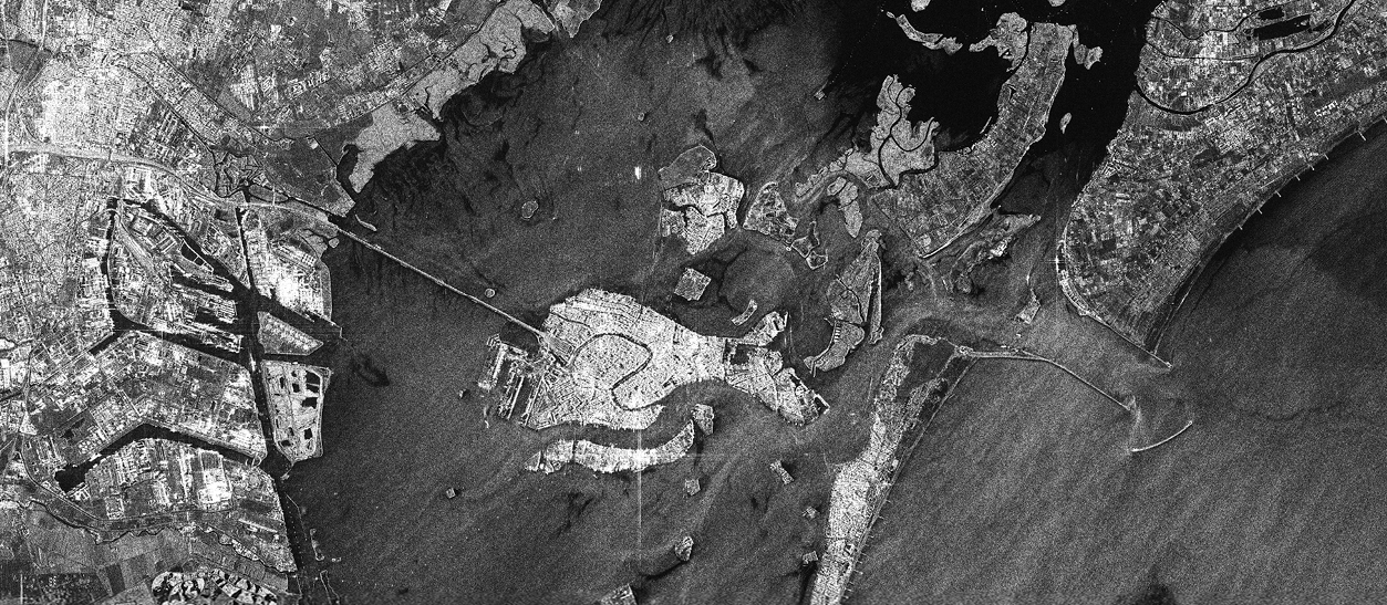
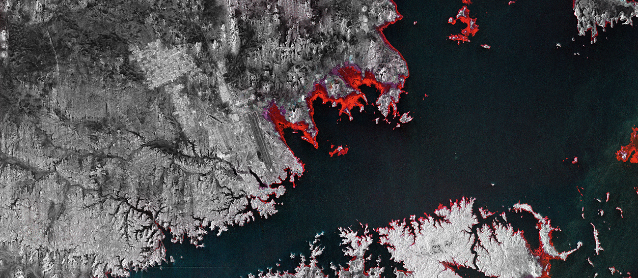
Lake Nasser, also called Lake Nubia, is a vast reservoir in southern Egypt and northern Sudan. It is one of the largest man-made lakes in the world, nearby the Abu Simbel archaeological site  (a UNESCO world heritage site). In the 1960s, President Nasser decided to build the Aswan High Dam across the Nile, forming this huge lake; the new dam provided inhabitants with water to drink and for irrigation.  The creation of the lake risked submerging a number of important historical sites — notably the tombs and temples at Philae and Abu Simbel—under its waters.  The Egyptian government appealed to UNESCO, which lent assistance by having many of the monuments dismantled and reconstructed on safer ground.  In this Multi-temporal picture of Lake Nasser, the coloured areas correspond to those acquired in various months throughout 2017: the red ones in July, the green ones in November and the blue in September. The most evident feature is the variability of the level of the artificial lake, particularly low in July (the red areas are the driest).

Lake Nasser, Egypt

COSMO-SkyMed image © ASI Processed and distributed by e-GEOS

February 2019


The Danube, the second longest river in Europe, was once a long-standing frontier of the Roman Empire.

The exceptional importance of this international “waterway” in Europe is derived from its geographical location and the direction its waters flow: beginning in Germany and flowing into the Black Sea, crossing the territories of 10 countries, more than any other river in the world, it flows through 4 capitals and changes its name, depending on the country it is flowing through. The river has always been a place of trade, transport, connection as well as nature, fertility, rich biodiversity; as Napoleon said “it is the king of European rivers”.  Danube Delta is a UNESCO World Heritage site, where the Danube meets the Black Sea and is the second largest and best preserved delta in Europe.  It covers 2,200 square miles of rivers, canals, marshes, tree-fringed lakes and reed islands.  The Danube Delta Biosphere Reserve has the third largest biodiversity in the world (over 5,500 flora and fauna species). The Danube Delta is a paradise for wildlife enthusiasts.

Danube Delta, Romania

COSMO-SkyMed image © ASI Processed and distributed by e-GEOS

March 2019


Clew Bay is the most spectacular bay in Ireland, a place where land and sea meet and merge together. It has amazing examples of sunken drumlins (elongated hills shaped like whalebacks), formed when glaciers reshaped the landscape in the last ice age. And now the islands have strange shapes and look like fish made out of stone floating in the water.  Legend has it that the there are 365 islands in the bay, one for each day of the year. The biggest, Clare Island, is the home to 130 people. Most of the others are uninhabited. John Lennon owned and stayed on Dorinish Island, a remote island in Clew Bay, which he planned to turn into a hideaway retreat and, talking about this small island, Yoko Ono once said: “a place where we thought we could escape stress and spend some time alone together”.

Clew Bay, Ireland

WorldView-2 image © DigitalGlobe

April 2019


In the Lower Danube the natural dynamics of the river have built and re-built countless islands home to floodplain ecosystems.  The islands are important migratory elements on the Danube.  The Great Island of Braila, is a wetland separated from the mainland by two branches of this navigable river. The Grande Brăila Island covers a total area of 710 km² and 94.6% of the area is occupied by agricultural land.  Whilst the territories around Braila are cultivated with corn, rape, wheat and alfalfa.  In addition to the hunting areas, there are also about 3,000 hectares of rice fields. The city of Brăila enjoyed a period of great splendour at the turn of the nineteenth and twentieth centuries thanks to its position on the Danube and subsequent strategic importance for trade; the local economy is in fact based on the great volume of grain traded and a large port area.

The island of Grande Brăila, Romania

WorldView-2 image © DigitalGlobe

May 2019


Guajará Bay marks off the city of Belém, capital of the Pará State, in the Amazon Region. It is formed by the confluence of rivers Guamá and Acará. Belém, is full of bays and creeks forming islands all around it; there are 55 of these islets, most of which are wild.  Founded in 1616, it was the city from where the occupation of the Amazon Region began. With its privileged position, it is a very important distribution point for products to and from the entire Amazon Region. Belem has the highest population density in the region (about 1,500,000 people); this creates problems for the city’s water and waterworks operators. All the waste waters are discharged into Guajará Bay or River Guamá. A growing level of pollution has been observed on the beaches located in the islands near the city of Belém.

The Guajará Bay, Belém, Brazil

COSMO-SkyMed image © ASI Processed and distributed by e-GEOS

June 2019


The artificial Paranoá Lake in Brasilia was constructed in 1959, three years after the city had been built, starting from scratch “en el medio de la nada” as the president Juscelino Kubitschec said, who had ordered the construction of this surreal city, designed by the visionary architect Niemeyer as a “dynamic curve, like the ocean waves”, he said. The Paranoà River was dammed to create this lake with the purpose of raising the land’s degree of humidity, since Brasilia is naturally very dry.  In 1987 Brasilia was registered as a World Heritage Site by UNESCO, the only one built from scratch in the twentieth century. It was known as “Fantasy Island” for its modern architecture and utopian urban planning. The Juscelino Kubitschek bridge (named after the President), architectural icon of the city, referred to as the most beautiful in the world, spans the lake. It was designed by architect Alexandre Chan; the weight of the extravagant structure is supported by three steel arches  on different planes, like the triple bounce of a stone thrown into the water.

Brasilia, Paranoà Lake, Brazil

WorldView-2 image © DigitalGlobe

July 2019


Ancient Egyptians lived near the longest river in the world, as it provided water, food, transportation and rich alluvial mud for growing food; rainfall is almost non-existent in Egypt and flooding provided the only source of water for the crops. Its ancient name was Ar (black) because of the colour of the sediment left after the river’s annual flooding. Further away from the river was the Red Land, a region of inhospitable desert. The annual flooding is now controlled by the Aswan Dam. The Nile is therefore an essential source of life and sustenance, and has attracted an increasing number of people; a population that, together with demography, has above all developed the building industry. Cairo is one of the world’s most rapidly growing cities, with a population growing by almost two percent per year. Urban development as photographed from COSMO-SkyMed in a 7-year period. By using colours it is possible to see the changes taking place with time: no coloured urban details were found in the 2011 image. Yellow areas were built between 2011 and 2014 and Red areas were built after 2014.

Nile, Cairo. Egypt

COSMO-SkyMed image © ASI Processed and distributed by e-GEOS


August 2019


The Thames estuary is where the River Thames flows into the North Sea in south-east England.  According to a hydrological study conducted between 1882 and 1889 it is believed that its western border lies around Canvey Island, along a north-south line between North Foreland in Kent and the Kentish Knock lighthouse at Harwich in Essex. The area is described by Conrad in the first pages of his novel “Heart of Darkness”, as both the departure point of the great British exploration and colonization ships as well as a site colonized by the Roman Empire in the British Isles. London Array, the world’s largest offshore wind farm, lies to the east in the outer Thames estuary. It produces 630 MW and is expected to produce enough clean energy to satisfy the demand of around half a million UK homes each year.  Savings in C02 are estimated at around one million tons per year.

The Thames estuary, Great Britain

COSMO-SkyMed image © ASI Processed and distributed by e-GEOS

September 2019


The Severn Bridge is a key artery between England and Wales crossing over the River Severn and is essential to the economy of the country. The original Severn Bridge revolutionized transport in Wales when it was built. The link par excellence between land and water is represented by a bridge. The bridge has always been an undisputed symbol of passage, a critical but also a salvific place, as a symbol of unity: a bridge spanning a river connects one bank to the other and the Severn Bridge is only one of the many bridges (over one hundred) built in the past centuries to connect the two banks of River Severn. Some of them have become national monuments, such as the Atcham Bridge, the Over Bridge and the Iron Bridge. Severn Bridge, opened in 1966, replaced the ferry line between Aust (in England) and Beachley (in Wales).  As the Queen said when she officially opened the bridge: “It offers a new economic era for South Wales”.

Severn Bridge, United Kingdom

WorldView-2 image © DigitalGlobe

October 2019


The Colorado River flowing into the Gulf of California, also referred to as the Sea of Cortés, is pictured in this satellite image.  The delta is located between the two Mexican states of Baja California (left) and Sonora (right). Known for its incredible canyons, whitewater rapids, and eleven U.S. National Parks, the Colorado River and its tributaries are a vital source of water for 40 million people. The river stretches for about 2,330 km and, due to its capacity, large basins have been built for hydroelectric plants in its lower course, but the massive collection of its water for irrigation in the Imperial Valley, and civil uses, has drained its low course (in Mexico) to such an extent that there are years when the river fails to reach the sea.  The Upper Gulf of California and Colorado River Delta were registered by UNESCO as a Biosphere Nature reserve. A large portion of the Biosphere reserve has been included in the RAMSAR list of wetlands of international importance.

Colorado River Delta, Gulf of California

DEIMOS-2 Image © Deimos imaging an UrtheCast Company

November 2019


Located in the rural Jiangxi Province, Poyang Lake is one of the country’s most popular tourist attractions.  Its surface ranges from 1000 km² in the dry season to over 4400 km² in the wet season. With an average depth of 8.4 m, Poyang Lake is fed by 5 rivers, the two main ones being Rivers Gan and Xiu. Unfortunately, due to drought, the lake has now lost 90% of its water. Because of this, in January 2014, the ruins of a bridge of about 3 km in length were brought to light, built over 400 years ago during the reign of the Ming emperors and thereafter falling into oblivion. Lake Poyang is the habitat of half a million migratory birds.  During the winter it hosts many Siberian cranes that come here to winter.

Poyang Lake, China

DEIMOS-2 Image © Deimos imaging an UrtheCast Company

December 2019


For over a thousand years the city of Venice has been the capital of the Venetian Republic and was called “Serenissima”,  the Dominant, and the Queen of the Adriatic.  With its characteristic urban planning and artistic heritage, Venice is universally considered one of the most beautiful cities in the world and is included, together with its lagoon, among the UNESCO World Heritage sites in Italy. The city of Venice is affected by subsidence mainly due to natural and anthropogenic causes, and to the eustatism linked with global climatic changes: from the beginning of the last century to the ’70s, the sea water level rose by 9 cm in Venice. Venice has always been intimately linked with the water surrounding it. In the ancient and mystical annual Marriage of the Sea ceremony, established in AD 1000, the Doge (elected ruler of the Republic) threw a consecrated ring into the murky waters  and declared the city and sea to be an indissoluble oneness.

The Venetian Lagoon, Italy

COSMO-SkyMed image © ASI Processed and distributed by e-GEOS