


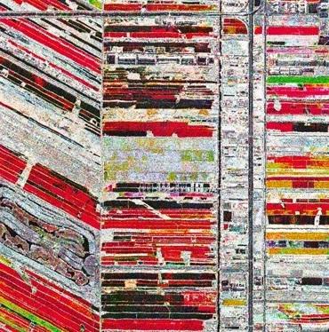
The eye of the satellites is able to observe the entire surface of our planet, watching day and night the entire path that goes from plowing to sowing, up until harvest. Satellites observe the territory allowing us to monitor continuously the condition of the soil and the products being grown, enabling a true "precision agriculture".
The use of satellite geo-positioning technology, also associated with the use of "smart labels", can allow product origin certification, contributing to their enhancement.
All this is told in a video made by Telespazio using optical and radar satellite images processed by e-GEOS. It offers a virtual flight over the immense crops of corn and rice that feed billion people. The proper management of these resources, with an environmentally friendly exploitation of the planet’s soil, will lead to a better life on Earth.
Clusters are one of the new features of Expo Milano. For the first time, fifty countries are gathered in pavilions arranged not geographically, but rather by thematic identities or food production chains: Rice; Cocoa and chocolate; Coffee; Fruit and vegetables; Spices; Cereals and tubers; Bio-Mediterranean; Islands, sea and food; Arid areas.
Telespazio in particular collaborates with the clusters "Cereals and tubers" and "Islands, sea and food", to illustrate how the use of satellite technology, and all the applications and services connected with it, play an important and innovative role in the monitoring and management of heterogeneous areas and environments: in agriculture, forestry and fishing.
Finmeccanica is pleased to contribute with its skills and activities to the sustainable development of our planet, offering innovative solutions and an efficient use of satellite technology in the service of a fundamental common asset: our Mother Earth.